Analysis · StrikeOrbit | 2026
You cannot defend what you cannot see. In the orbital domain, this principle has consequences that extend far beyond the immediate loss of a satellite or the disruption of a communications link. Space situational awareness — the ability to detect, track, identify, characterise, and attribute the behaviour of objects and events in Earth’s orbital environment — is the foundational intelligence capability on which every other aspect of space operations depends.
Without it, counter-space threats cannot be detected before they act.
Without it, the ambiguous manoeuvres of co-orbital systems cannot be attributed.
Without it, debris from anti-satellite tests cannot be tracked, and the collision risks they pose cannot be managed.
Space situational awareness is not a supporting function of space operations. It is their prerequisite.
The strategic significance of SSA has grown in direct proportion to the contested character of the orbital environment. As examined in What Is Orbital Warfare? How Space Became a Contested Military Domain.
Space has transitioned from a domain of informal restraint to one of active military competition across multiple dimensions. The same transition that has driven investment in anti-satellite weapons, co-orbital systems, and directed energy capabilities has driven investment in the awareness infrastructure needed to monitor those capabilities — to know where adversary spacecraft are, what they are doing, and what they are likely to do next.
SSA is simultaneously a defensive necessity and an offensive enabler. A state with superior space domain awareness can detect threats earlier, respond more effectively, and conduct its own proximity operations with greater precision than one operating with incomplete knowledge of the orbital environment.
The competition over space situational awareness is therefore not a technical footnote to the broader space competition. It is one of its central dimensions — and the outcome of that competition will shape who can act in orbit with confidence and who must act in the dark.
Space Situational Awareness Became a Strategic Imperative as the Orbital Environment Grew Contested
The history of space situational awareness begins with the same recognition that drove the development of anti-satellite weapons: that objects in orbit can be tracked, and that tracking them provides military advantage. The United States began developing systematic space surveillance capabilities in the late 1950s, initially focused on tracking Soviet satellites during the early space race.
The Space Detection and Tracking System, established in 1961, created the first dedicated network of sensors for monitoring objects in orbit — a capability driven not by debris management concerns but by the military imperative to know what adversary spacecraft were doing.
Throughout the Cold War, space surveillance remained largely a bilateral US-Soviet concern. Both sides maintained awareness of each other’s satellite constellations, tracked launches, and monitored orbital manoeuvres. The informal restraints on counterspace operations that characterised the latter Cold War period depended in part on mutual awareness — each side could see what the other’s satellites were doing, which reduced the likelihood of miscalculation.
The post-Cold War expansion of commercial space activity, combined with the proliferation of debris from launch activities and fragmentation events, transformed space situational awareness from a bilateral military concern into a global environmental management challenge.
The 2007 Chinese anti-satellite test generated the largest single debris cloud in the history of spaceflight. The 2009 collision between Iridium 33 and Cosmos 2251 — the first accidental collision between two intact satellites — demonstrated that the orbital environment was approaching a density at which unmanaged conjunction risks would become operationally significant. Both events accelerated investment in SSA capabilities across multiple spacefaring nations.
The shift that defines the current period is the convergence of debris management concerns with active counterspace threat monitoring.
Space situational awareness today must simultaneously track tens of thousands of debris objects, monitor hundreds of active commercial and government satellites, characterise the manoeuvres of suspected co-orbital weapons systems, and provide the attribution data needed to support diplomatic and military responses to threatening orbital behaviour. These are not separate missions sharing infrastructure. They are interdependent functions of a single awareness requirement that no existing system fully satisfies.
The Architecture of Space Situational Awareness: Sensors, Data, and Attribution
Space situational awareness depends on a layered architecture of ground-based and space-based sensors, data processing systems, and analytical frameworks for characterising and attributing orbital behaviour. This architecture defines not just what can be seen, but what can be missed — and those gaps are where adversaries operate.
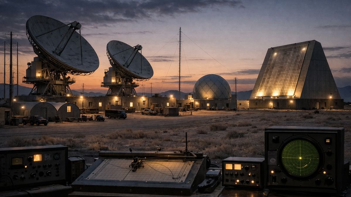
Ground-based radar systems provide the primary detection and tracking capability for objects in low Earth orbit.
Mechanical radars — large dishes that physically rotate to track objects — provide high-resolution tracking of individual objects but have limited fields of view and cannot simultaneously monitor large areas of the sky.
Phased array radars overcome this limitation by electronically steering their beams across wide areas without mechanical movement, enabling simultaneous tracking of hundreds of objects. The United States Space Surveillance Network, operated by the Space Force, includes both mechanical and phased-array radars distributed across multiple sites globally, providing ground-based coverage of the orbital environment.
The Space Fence, the most significant recent upgrade to American ground-based SSA infrastructure, represents a generational improvement in detection capability.
Located on Kwajalein Atoll in the Marshall Islands and declared operational in 2020, Space Fence is an S-band phased array radar capable of tracking objects in low Earth orbit smaller than a softball — a capability that substantially expands the catalogue of tracked objects and enables detection of debris and spacecraft that previous sensors could not resolve. Its location in the equatorial Pacific provides optimal coverage of the orbital planes most densely populated by active satellites and debris.
Optical sensors — telescopes operating in visible and infrared wavelengths — provide complementary capability to radar systems, particularly for tracking objects in medium Earth orbit and geostationary orbit, where radar coverage is less effective due to the distances involved. The Ground-Based Electro-Optical Deep Space Surveillance system, or GEODSS, operates a network of optical telescopes providing coverage of the deep space orbital environment where high-value geostationary communications and early warning satellites operate.
The Space Force’s Space Domain Awareness Strategy, published in 2023, outlines the doctrine governing how these sensor systems are integrated into operational awareness.
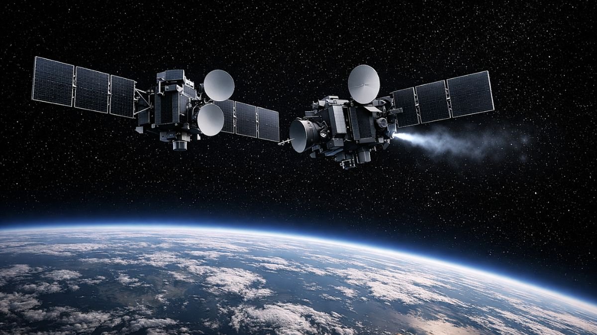
Space-based sensors represent the frontier of SSA capability development. Sensors in orbit can observe the orbital environment from vantage points inaccessible to ground-based systems, provide coverage of orbital regions that ground systems cannot effectively monitor, and conduct close-approach inspection of specific spacecraft of interest.
The United States’ Geosynchronous Space Situational Awareness Programme — GSSAP — operates satellites in near-geostationary orbit specifically for the inspection and characterisation of other objects in that regime. As examined in Anti-Satellite Weapons: Capabilities, Systems, and Strategic Implications, GSSAP satellites conduct the same category of co-orbital proximity operations that Washington publicly criticises when conducted by Russia and China — illustrating the dual-use reality of advanced SSA capabilities.
Data processing and catalogue management are the less visible but equally critical components of SSA architecture.
The 18th Space Control Squadron, operating from Vandenberg Space Force Base, maintains the authoritative catalogue of tracked space objects — currently comprising over 27,000 objects larger than ten centimetres in low Earth orbit — and provides conjunction assessment services to satellite operators worldwide.
The catalogue is updated continuously as new observations are processed, and conjunction alerts are issued when the probability of collision between two tracked objects exceeds defined thresholds. This service is provided publicly to commercial and government operators globally, making the United States the de facto provider of space traffic management services for the international community.
A 2021 CNA analysis of space domain awareness argued that effective orbital awareness is becoming essential not only for collision prevention, but for deterrence, attribution, and military decision-making in contested space environments.
Tracking objects is awareness. Understanding behaviour is power.
The Commercial SSA Revolution Is Reshaping the Domain
Orbital awareness is no longer a government-controlled domain. Commercial SSA is no longer supplementary. It is becoming structural to how orbital awareness is generated and shared. In orbit, data is no longer owned. It is aggregated.
Commercial SSA is reshaping who sets the rules of visibility in orbit.
LeoLabs, a California-based company, operates a global network of phased-array radars specifically designed to track objects in low Earth orbit. Its sensor network provides commercial conjunction assessment services with tracking capabilities that complement and in some respects exceed those of government systems for specific orbital regimes.
ExoAnalytic Solutions operates a global network of optical telescopes providing commercial tracking and characterisation services for geostationary and deep space objects. Slingshot Aerospace integrates data from multiple sensor sources into a commercial space situational awareness platform that provides operators with real-time conjunction assessment and orbital intelligence.
Commercial SSA changes not just capability, but who controls access to orbital knowledge.
Commercial SSA providers can operate with fewer classification constraints than government systems, enabling broader data sharing with allied nations, commercial operators, and international organisations.
They can deploy sensors at commercially negotiated sites globally, including in geographic regions where government sensor placement would be diplomatically or operationally sensitive. And they can develop and iterate sensor and software capabilities at the pace of commercial technology development rather than the slower cycles of government acquisition.
The integration of commercial SSA data with government systems is becoming a deliberate architectural choice rather than an emergency supplement. The Space Force has established data-sharing arrangements with multiple commercial SSA providers, and the Open Architecture Data Repository — the government data framework that underpins JADC2-connected space domain awareness — is designed to ingest commercial SSA data alongside government sensor data into a common operational picture.
As examined in JADC2 Explained: How the US Military’s Joint Command Network Works, this integration of commercial data into military operational frameworks reflects the same architectural logic that has driven commercial satellite constellation integration into military communications.

Adversary SSA Programmes Are Expanding the Competition
The United States no longer holds uncontested dominance in space situational awareness capability, and the competitive dynamics of SSA development are increasingly important to understanding the broader space competition. Both China and Russia have invested substantially in SSA capabilities, motivated by both the defensive need to protect their own satellite constellations and the offensive utility of superior orbital awareness for conducting and attributing counterspace operations.
China’s SSA programme has expanded significantly over the past decade. The PLA operates a network of ground-based radar and optical sensors providing coverage of multiple orbital regimes, and has deployed space-based SSA assets to extend its awareness into orbital regions inaccessible to ground systems.
The Tianmu weather satellite constellation, ostensibly commercial, has been assessed by Western analysts as incorporating SSA sensor capabilities alongside its declared meteorological mission — illustrating the dual-use approach to space capability development that characterises Chinese space programmes broadly.
China’s SSA capabilities are assessed to provide sufficient awareness to support the co-orbital proximity operations that its Shijian satellite series has conducted, and to enable the targeting solutions required for its direct-ascent ASAT missiles.
Russia’s SSA heritage is the deepest of any nation, deriving from the Soviet-era space surveillance network that supported the IS co-orbital ASAT programme from the late 1960s onward.
The Russian Space Surveillance System, operated by the Russian Aerospace Forces, maintains a network of radar and optical sensors providing global coverage of the orbital environment. Russia has demonstrated the ability to conduct close-approach inspection operations with co-orbital spacecraft — operations that require SSA precision sufficient to safely navigate a spacecraft to within metres of a target satellite.
The 2024 deployment of Cosmos 2576 into an orbital configuration threatening a US government satellite, publicly disclosed by the United States Space Command, demonstrated that Russian SSA capability is sufficient to support deliberate orbital positioning for strategic effect.
France, Japan, Australia, India, and the United Kingdom have all invested in national SSA capabilities as part of their broader space security programmes.
The French Space Command operates optical and radar sensors providing national SSA coverage with particular focus on geostationary orbit.
Japan’s Self-Defence Forces operate an SSA radar system and are developing space-based SSA assets in close coordination with the United States.
Australia hosts US Space Surveillance Network sensors on its territory and is developing its own national SSA contribution as part of the bilateral alliance framework.
India established its Space Situational Awareness Control Centre under ISRO in 2022, marking a significant step in developing sovereign orbital awareness capability independent of partner nation data.
The United Kingdom contributes to the Combined Space Operations framework through its Space Operations Centre at RAF High Wycombe, integrating British sensor data into the allied common operational picture.
The European Union’s Space Surveillance and Tracking programme coordinates SSA data sharing among European member states, providing a multilateral framework for orbital awareness that reduces dependence on US government data.
The Secure World Foundation’s counterspace assessment programme provides detailed open-source analysis of the surveillance, tracking, and counterspace capabilities shaping the modern orbital environment.
Attribution Is the Most Difficult and Most Consequential SSA Challenge
Tracking the position and trajectory of an object in orbit is technically demanding but achievable with sufficient sensor infrastructure. Attributing the intent behind an object’s behaviour — determining whether an orbital manoeuvre is routine station-keeping, inspection, or positioning for attack — is a fundamentally different and more difficult problem.
Attribution is where SSA capability translates into strategic decision-making, and it is where the current state of the art falls most significantly short of what the contested orbital environment demands.
Detection answers where something is. Attribution answers what it means.
The attribution challenge has several dimensions. Physical attribution — determining which state or operator controls a specific object — is complicated by the opacity of some national space programmes and the dual-use nature of commercial satellites.
Behavioural attribution — determining whether a specific manoeuvre pattern is consistent with hostile intent — requires a baseline understanding of normal orbital behaviour against which anomalous behaviour can be assessed, and that baseline is still being established for many categories of spacecraft.
Temporal attribution — determining whether observed behaviour is preparation for an imminent action or a long-term positioning — requires sustained observation over time periods that may exceed the decision timelines available in a crisis.
The 2024 Cosmos 2576 case illustrated both the progress and the limits of current attribution capability.
The United States Space Command was able to detect the satellite’s deployment, characterise its orbital parameters, assess its proximity to a US government satellite, and make a public attribution of hostile intent — all within a timeframe that allowed public disclosure and diplomatic response.
That represents a significant SSA and attribution capability. But the public disclosure also illustrated the limitations: the response to a satellite assessed as a co-orbital weapon was a statement, not a countermeasure. The awareness was sufficient to detect and characterise the threat. It was not sufficient — or the decision was not made — to prevent or neutralise it.
This gap between awareness and response is the central strategic challenge of space situational awareness in the current environment. Knowing that a threatening spacecraft exists, knowing where it is, and knowing what it appears to be doing does not automatically produce a response that neutralises the threat. It produces a decision point — and the quality of that decision depends on the speed, accuracy, and completeness of the awareness that preceded it.
The Future of SSA: Proliferated Sensors, AI Processing, and Allied Integration
The trajectory of space situational awareness development points toward three converging trends that will define the domain’s capability over the next decade. Each trend addresses a current limitation in ways that will meaningfully change the strategic balance of orbital awareness.
Proliferated space-based sensors represent the most significant near-term capability development. Ground-based sensors are constrained by geography, weather, and the physics of observing fast-moving LEO objects from the ground. Space-based sensors embedded within satellite constellations can provide continuous, all-weather, all-orbit coverage from vantage points that ground systems cannot match.
The Space Force’s Space Domain Awareness programme is investing in hosted payloads — SSA sensors embedded within operational satellites — that provide persistent monitoring of the orbital environment from within it.
Several commercial SSA providers are developing dedicated SSA satellite constellations that will dramatically expand the volume and quality of observational data available. By the end of the decade, the combination of proliferated government and commercial space-based sensors is expected to reduce significantly the blind spots in current SSA coverage.
Artificial intelligence and machine learning are becoming essential to SSA data processing at the volumes that proliferated sensor networks will generate.
The current United States SSA architecture processes sensor data through a combination of automated algorithms and human analyst review. As sensor proliferation increases the volume of observational data by orders of magnitude, human review of individual observations becomes operationally impractical.
AI systems that can autonomously process sensor data, update the object catalogue, generate conjunction assessments, and flag anomalous behaviour for human review are transitioning from research programmes to operational deployment.
The same GIDE experiment series that demonstrated AI utility for JADC2 kill chain compression has included SSA applications — demonstrating that AI-driven orbital awareness can compress the time from observation to actionable assessment in ways that manual processes cannot approach. Speed of understanding, not volume of data, will define future SSA advantage.
Allied SSA integration represents a third dimension of capability development with strategic implications beyond the technical. A network of allied SSA sensors distributed across multiple geographic regions provides coverage that no single nation’s sensor network can replicate.
Data sharing arrangements between the United States, United Kingdom, Australia, Canada, France, Germany, Japan, India, and other partner nations are creating a Combined Space Operations framework in which SSA data from multiple national networks is integrated into a common operational picture accessible to all participants.
This allied SSA network is harder for adversaries to blind comprehensively — degrading one nation’s sensors does not degrade the network — and provides the attributional corroboration that single-source observations cannot.
The United Nations Office for Outer Space Affairs maintains the Long-Term Sustainability Guidelines framework, which provides the normative foundation for international SSA data sharing and space traffic coordination.
Conclusion
Space situational awareness is not a technical capability in search of a strategic rationale. It is the foundational intelligence requirement for every dimension of space operations — defensive, offensive, diplomatic, and commercial simultaneously. The ability to see the orbital environment clearly, to characterise the behaviour of objects within it accurately, and to attribute threatening actions to their authors with sufficient confidence to support decision-making is the prerequisite for everything else that happens in space.
The competition over SSA capability is accelerating alongside the competition over counterspace weapons and resilient satellite architectures. States that achieve superior orbital awareness will be able to operate in space with greater confidence, detect threats earlier, respond more effectively, and conduct their own operations with greater precision. States that operate with degraded or incomplete awareness will face the strategic equivalent of fighting in the dark — able to act, but unable to see the consequences of their actions or the threats developing around them.
As the orbital environment grows more congested, more contested, and more consequential to military operations on Earth, the ability to see it clearly becomes more valuable and more contested simultaneously. Space situational awareness is where the space competition is most transparent — because it is literally the competition over who can see what is happening. In orbit, the side that sees first does not just understand the fight. It shapes it.
Frequently Asked Questions
What is space situational awareness and why does it matter?
Space situational awareness, or SSA, refers to the ability to detect, track, identify, and characterise objects and events in Earth’s orbital environment. It encompasses tracking debris, monitoring active satellites, detecting threatening manoeuvres by adversary spacecraft, and attributing orbital behaviour to specific actors. SSA matters because it is the foundational intelligence requirement for all space operations — without it, counterspace threats cannot be detected, collision risks cannot be managed, and the attribution of threatening behaviour cannot be established. In a contested orbital environment, superior awareness translates directly into strategic advantage.
How does the United States track objects in space?
The United States maintains the world’s most extensive space surveillance network, operated by the Space Force’s 18th Space Control Squadron. The network includes ground-based phased array radars — including the Space Fence on Kwajalein Atoll, declared operational in 2020 — mechanical tracking radars, optical telescopes, and space-based sensors, including the GSSAP co-orbital inspection satellites. The network currently tracks over 27,000 objects larger than ten centimetres in orbit and provides conjunction assessment services to satellite operators globally. Commercial SSA providers, including LeoLabs and ExoAnalytic Solutions, augment government capabilities with their own sensor networks and data services.
What is the difference between space situational awareness and space domain awareness?
Space situational awareness historically referred specifically to the tracking of physical objects in orbit — satellites, debris, and launch vehicles. Space domain awareness is a broader concept that encompasses not only physical object tracking but also the characterisation of the electromagnetic environment in orbit, the monitoring of adversary space operations and intent, the assessment of threats to space systems, and the integration of orbital awareness with broader intelligence about adversary space programmes. The US Space Force formally adopted the term space domain awareness to reflect this expanded scope, which includes understanding not just where objects are but what actors intend to do with them.
Which countries have significant space situational awareness capabilities?
The United States operates the most extensive SSA network globally, sharing data through the Combined Space Operations framework with the United Kingdom, Australia, Canada, France, Germany, Japan, and other allied partners. Russia maintains substantial SSA heritage derived from Soviet-era infrastructure, with capabilities sufficient to support co-orbital proximity operations. China has invested significantly in SSA expansion, with ground-based and space-based sensors supporting both debris tracking and counterspace targeting. India established its Space Situational Awareness Control Centre in 2022. France, Japan, Australia, and the UK all operate national SSA capabilities contributing to allied frameworks. Commercial SSA providers are increasingly significant global contributors.
How does space situational awareness relate to preventing conflict in orbit?
SSA contributes to conflict prevention through several mechanisms. Accurate tracking and attribution reduce the risk of misidentifying debris or satellite manoeuvres as hostile actions, which could trigger unnecessary escalation. Transparent data sharing between spacefaring nations — through mechanisms like the conjunction assessment services provided by the 18th Space Control Squadron — builds confidence and reduces the uncertainty that generates crisis instability. The ability to publicly attribute threatening orbital behaviour, demonstrated by the US Space Command’s 2024 disclosure of Russia’s Cosmos 2576 deployment, creates accountability for aggressive actions that might otherwise occur undetected. However, SSA also enables offensive counterspace operations, meaning its contribution to stability depends heavily on the norms and restraint of the actors who possess it.
Sources and References
U.S. Space Force — Space Capstone Publication (2020)
U.S. Space Force — Space Domain Awareness Strategy (2023)
Space Development Agency — Space Domain Awareness Programme Documentation (2024)
18th Space Control Squadron — Space Surveillance Catalogue and Conjunction Assessment Services (2025)
Space Fence Programme Office — Space Fence System Description (2020)
Congressional Research Service — Space Domain Awareness: Background and Issues for Congress (2023)
Secure World Foundation — Global Counterspace Capabilities: An Open Source Assessment (2026)
Government Accountability Office — Space Domain Awareness: Additional Actions Needed (2024)
Center for Naval Analyses (CNA) — Space Domain Awareness as a Strategic Counterweight (2021)
Center for Strategic and International Studies (CSIS) — Space Threat Assessment (2025)
Secure World Foundation — Global Counterspace Capabilities: An Open Source Assessment (2024)
LeoLabs — Commercial Space Situational Awareness Capability Overview (2024)
European Space Agency — Space Surveillance and Tracking Programme Documentation (2024)
United Nations Office for Outer Space Affairs — Long-Term Sustainability of Outer Space Activities Guidelines (2019)
Related Analysis
For analysis of the foundational orbital warfare context within which space situational awareness operates as the primary intelligence layer, read What Is Orbital Warfare? How Space Became a Contested Military Domain.
For analysis of the anti-satellite weapons that SSA is designed to detect, track, and attribute before they act, read Anti-Satellite Weapons: Capabilities, Systems, and Strategic Implications.
For analysis of how the United States and China are building competing space architectures in which SSA plays a central role, read US Space Force Doctrine vs China’s Space Strategy: Competing Visions of Orbital Power.
For analysis of the satellite communications infrastructure that SSA is designed to protect by providing early warning of threatening approaches, read Satellite Constellations and Military Communications in Modern Warfare.
For analysis of the JADC2 command network that integrates SSA data into joint military decision-making, read JADC2 Explained: How the US Military’s Joint Command Network Works.
